Horrifying Wind Gusts of 78 and 76 Reported in New Orleans

Ferocious Francine lashes Louisiana with destructive winds, flooding rain as storm weakens to tropical storm
Francine has been downgraded to a tropical storm, but the effects of the once Category 2 hurricane continue in Louisiana and the Southeast as more than 400,000 utility customers are plunged into darkness while torrential rain led to numerous reports of flooding.
NEW ORLEANS – Francine was downgraded to a tropical storm overnight after slamming the Louisianacoast as a Category 2 hurricane on Wednesday. It packed destructive 100-mph winds and a dangerous storm surge that knocked out power to hundreds of thousands of utility customers in the Southeast and dumped several inches of rain that led to a rare Flash Flood Emergency.
The eye of then-Hurricane Francine moved onshore at 5 p.m. CT in Terrebonne Parish, pushing hurricane-force wind gusts into the southern region of the state near Baton Rouge.
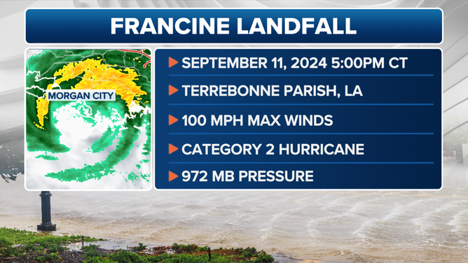
Hurricane Francine landfall on Wednesday, Sept. 11, 2024.
(FOX Weather)
New Orleans reported wind gusts of 78 and 76 mph as Francine’s eyewall came through the Big Easy on Wednesday evening, while Dulac reported a wind gust of 97 mph and Eugene Island saw a wind gust of 105 mph.
Francine has since been downgraded to a tropical storm, but the storm’s dangerous and life-threatening impacts are expected to continue well inland.

(FOX Weather)
Power outages continued to climb throughout Wednesday and into Thursday morning, with nearly 400,000 outages being reported in Louisiana and nearly 17,000 in Mississippi, according to PowerOutage.us.
A Flash Flood Emergency was issued for parts of the New Orleans metro where 0.50 inches of rain fell in just 9 minutes and 4.5 inches fell within 3 hours as rain still fell, with life-threatening flooding possible.
New Orleans International Airport officially had its second-wettest September day on record Wednesday with 7.33 inches. It was also the city's ninth-wettest day overall since 1946.
As the water rose, calls for help began to be received from those who had become trapped and could not escape.
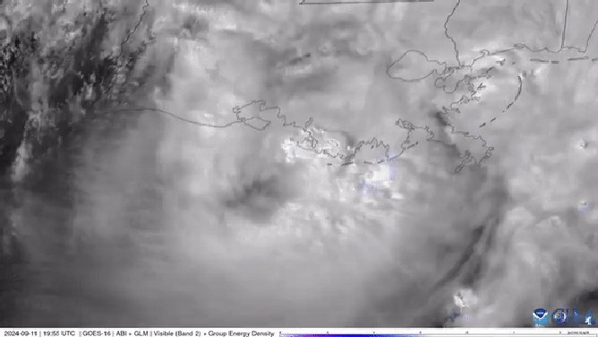
Hurricane Francine landfall satellite.
(NOAA)
According to information provided by Lafourche Parish Sheriff Craig Webre, more than two dozen people, including small children, needed to be rescued from the flooding.
The sheriff's office said deputies responded to a call from residents who were trapped in housing units in Thibodaux due to the rising floodwaters caused by the torrential rain.
All the residents were safely evacuated from the area, and most were taken to emergency shelters.
Conditions created by Francine also brought the threat of tornadoes and severe thunderstorms, which were expected to last into Friday morning.

Francine halts New Orleans travel with emergency responders standing by
Travel in the area has also been impacted after airlines canceled flights into and out of the Louis Armstrong New Orleans International Airport through Thursday morning.

Hurricane debris whips past reporter during live coverage of Francine in Louisiana
FOX Weather's Robert Ray was in Houma, Louisiana, when Hurricane Francine made landfall Wednesday afternoon. Debris can be seen blowing past Ray during live coverage.
Some parishes issued mandatory curfews from Wednesday afternoon until sunrise on Thursday, including Cameron Parish, where flooding occurred prior to landfall.
Ahead of Francine's arrival, President Joe Biden approved an emergency declaration for the Bayou State.
"After declaring a state of emergency, we have now determined that this storm is of such severity that an effective response is beyond the capabilities of the state and local governments," Louisiana Gov. Jeff Landry said. "This federal assistance is needed to save lives and property."

Storm surge overtakes Louisiana marina
Terrebonne Parish saw several feet of storm surge ahead of the arrival of Hurricane Francine on Wednesday.
Where is Francine headed next?
The National Hurricane Center (NHC) said Francine is expected to take a gradual turn toward the north, bringing the center of the tropical storm across southeastern Louisiana and southwestern and central Mississippi on Thursday.
The center of circulation is expected to continue well inland, but the storm’s impacts could expand outward hundreds of miles.
LOUISIANA RESIDENTS SCRAMBLE FOR SUPPLIES AHEAD OF HURRICANE FRANCINE
Weather alerts, such as Wind Advisories, Flood Watches and other hazardous weather outlooks, have been posted as far north as southern Missouri and as far east as Tennessee as what is left of the tropical cyclone makes its way through the South.
Including Francine, eight hurricanes have made landfall in Louisiana since 2000. FOX Weather Correspondent Robert Ray has covered most of those landfalls.
"These people are tough as nails," Ray said from Houma, Louisiana. on Wednesday.
Francine became a hurricane on Sept. 10, marking the peak of the 2024 hurricane season when a named storm is most likely to be roaming the Atlantic Basin. As Francine heads north and eventually dissipates, the NHC is also tracking several other systems in the Atlantic.

Unrelenting wind pummels southern Louisiana as Hurricane Francine nears landfall
Powerful winds cause tree branches to thrash and rain to fall horizontally as Hurricane Francine nears landfall as a category 2 hurricane. FOX Weather Storm Specialist Mike Seidel reports. Sept. 11, 2024.
Francine was the third hurricane to make landfall in the continental U.S. during the 2024 season. Hurricane Beryl made landfall in Matagorda, Texas, on July 8 as a Category 1 storm. About a month later, Hurricane Debby strengthened into a Category 1 before making landfall near Steinhatchee, Florida, on Aug. 5


.jpeg)
Comments
Post a Comment